Proposal to Recognise Seaport as an Unbounded Locality
The area to the north of Royal Park, at the meeting point of the Kanamaluka / River Tamar and North Esk River, has been commonly known as Seaport for many years. However, this name has never been formally recognised.
The City of Launceston is seeking community feedback on a proposal to officially recognise Seaport as an unbounded locality and place name.
Why name the area?
Providing Seaport with an official name would help strengthen the area’s identity and sense of place. It would allow Seaport to be clearly referenced in wayfinding, mapping and signage, support destination branding, and assist economic development for tourism and events. An official name would also make it easier for emergency services, locals and visitors to locate and navigate the area.
What is being proposed?
To formally recognise the name, the City of Launceston is required to apply to Placenames Tasmania. Following initial discussions, it is proposed that the City of Launceston apply for the creation of an 'unbounded locality' named Seaport.
What is an unbounded locality?
An unbounded locality is an area of community or cultural significance that has historical and local recognition, but no defined boundaries. Because it is unbounded, it does not result in any changes to property addresses. The name can, however, be used on maps and signage.
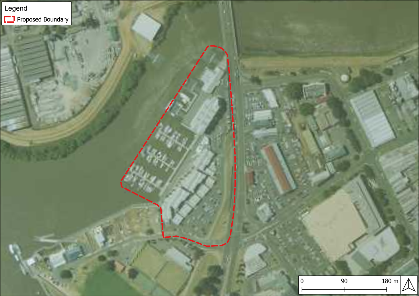
What area is being proposed?
View the proposed unbounded locality for Seaport here.
How does the process work?
We want to hear from the community to understand whether you support officially recognising the area as Seaport through the creation of an unbounded locality.
Once the feedback period has ended, and if there is community support for the proposal, the City of Launceston will submit an application to Placenames Tasmania for consideration.
The community will be informed of the outcome once a decision has been made.
FAQs
Frequently Asked Questions
History of 'Seaport'
Launceston has a long-standing identity as an inland port city, historically connected to trade and transportation via the Kanamaluka / River Tamar. The land encompassing the Seaport complex along the North Esk River is known to have been utilised for maritime pursuits since early European settlement.
Prior to the 1820, Launceston's harbour facilities are known to have consisted of little more than timber planks run out from the shoreline to ships moored off the Esplanade (Terry & Servant, 2002, p. 23). The establishment of Launceston as a significant seaport commenced from this time (Burgess 2022).
Launceston's seaport has been utilised for a variety of maritime endeavours including whaling and sealing expeditions, construction of ships, provision of ships for the pursuit of escaped convicts, goods trading and navy pursuits (Burgess 2022). The historic wharf at present-day Seaport was formerly known as 'Market Wharf'.
The Seaport complex as seen today was identified for development in 1999, with construction beginning in February 2001. The development comprised a boardwalk connecting Seaport and Royal Park, eight private land blocks for residential homes, 24 apartments and a hotel. The complex opened in March 2004 and has been utilised as a recreational/restaurant/hotel complex since this time (Geale 2023).
Home Point is already an unbounded locality which encompasses the southern end of the seaport (Bowling and Rugby clubs, Tamar River Cruises etc.) This unbounded locality was introduced in early 2000's.
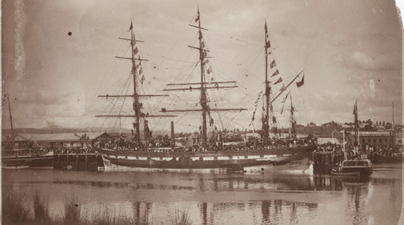
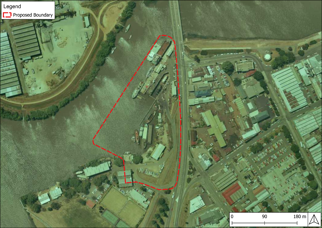
Figure 2: 1991 aerial imagery. showing utilisation for port activity with ships docked and the drydock in use (Source: DNRE Aerial Photograph).
Implementation
Should the proposal be approved, the following elements would be addressed:
- Signage and wayfinding - precinct signage, city maps and digital wayfinding would be updated to reflect the name change.
- Relevant agencies - emergency services, service providers and other relevant agencies would be notified of the name change.
- Communications - a public announcement inclusive of media release, newspaper advertisement and social media posts would be undertaken following the name change. Written notification would also be distributed to affected property owners, residents and businesses.


